7 Aug 2020
Cloud cover across the entire tile: 0.3 per cent.
Contains modified Copernicus Sentinel data 2020
Original dataset ↗ · Open image study area ↗
ORBIT · SATELLITE IMAGES
Satellite images of Copenhagen: compare summers, discover recent images and understand vegetation and water indicators.
Denmark · A harbour city between land and sea
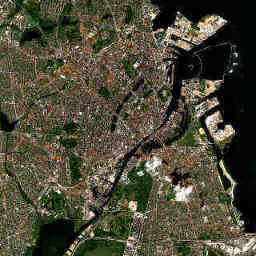
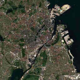
The image is temporarily unavailable. Acquisition details and the original source are below.
Taken by Sentinel-2C. See Sentinel-2C in the 3D orbit view →
Contains modified Copernicus Sentinel data 2020, 2026.
What does the sample show?
Indicators from Sentinel-2 scene classification. Not official green-space statistics or a measurement of the whole city.
Find the harbour basins and coastlines. Construction sites and new land require closer examination using the original data.
The images show the same study area. Acquisition dates, shadows and plant growth may still differ. Fixed study area: 12 × 12 km around the city centre. Not a municipal boundary. Reduced true-colour image, not a street map or live view.
Not every summer has a suitable clear image. Gaps remain visible; no intermediate values are invented.
| Summer | Acquired | Vegetation class | Water class | Classifiable |
|---|---|---|---|---|
| 2020 | 7 Aug 2020 | 35.9 % | 23.2 % | 99.7 % |
| 2026 | 9 Jul 2026 | 36.4 % | 23.1 % | 98.6 % |
Cloud cover across the entire tile: 0.3 per cent.
Contains modified Copernicus Sentinel data 2020
Original dataset ↗ · Open image study area ↗Cloud cover across the entire tile: 2.7 per cent.
Contains modified Copernicus Sentinel data 2026
Original dataset ↗ · Open image study area ↗Cloud cover across the entire tile: 0.2 per cent.
Contains modified Copernicus Sentinel data 2026
Original dataset ↗ · Open image study area ↗Sentinel-2 L2A, July and August; no more than 15 per cent cloud cover across the tile. All summers for a city use the same tile, projection and fixed study area. The true-colour channels are reduced for the preview.
A regular grid with 80-metre spacing reads the Sen2Cor scene classes. Only vegetation, non-vegetated surfaces and water count towards the classifiable sample. Clouds, shadows, snow, missing and uncertain classes are excluded. We publish no indicators when fewer than 85 per cent of points are classifiable.
The values describe a model-based sample on individual dates. Season, weather, water levels, harvest, processing and classification versions affect comparisons. Three summers do not establish a climate or urban-development trend.
Copernicus · Sen2Cor ↗ · Earth Search ↗
Earth Search / Element 84. Image search last checked: 29 Oct 2026
Map base: Natural Earth, public domain
No matching city. Try another name.
Automatically translated from German; some interface labels are reviewed. View original →. Some new text is still available in German.