
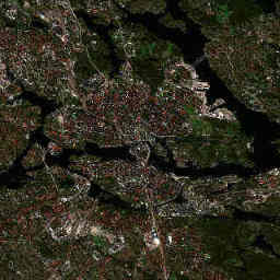
Currently available image of the fixed 12 × 12 km study area. The story explains landscape patterns, not automatically detected change.
Contains modified Copernicus Sentinel data 2026.Explore the image
Follow the water through the centre. Find the island of Djurgården east of the old town and the transitions between dense development and larger green spaces. Use the same shoreline shapes as landmarks in the comparison.
How to interpret it
Large connected areas of water and greenery shape the city. The image shows their spatial relationship and can prompt questions about accessible open space and connections between habitats. The image alone cannot tell us whether a shore is publicly accessible.
What it cannot tell us
Dark water does not prove pollution, and a green patch is not a biodiversity survey. Sun angle, shadows and plant development affect the image. Three summer acquisitions cannot establish a long-term climate trend here either.
What additional data could show
A future expansion could add official land-cover data and longer vegetation records. The Copernicus Land Monitoring Service provides separate, precisely defined products for this purpose. Their resolution and study areas would need checking before comparison with our samples.
Sources and further data
Editorial interpretation · Updated 29 October 2026. The image and its source details update automatically; the explanatory text is maintained editorially.